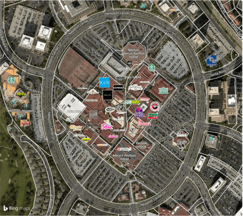
Have you or your team ever spent hours trying to overlay retail logos on a map?
When analyzing properties, a crucial aspect includes knowing what businesses are nearby. You may analyze neighboring properties, the population in an area, what the population in the area cares about, and even surrounding retailers. You may research all these data points as part of an acquisition, competitive analysis, or even to avoid certain populated areas altogether. Using LandVision™, a user is able to overlay national retailers on their map or even choose specific categories or individual retailers to call out on their map. This helps communicate quickly and effectively just the information you care to convey.

Here’s a Video to Show You How to Quickly Overlay Retail Logos on a Map:
How This Video Was Created
Using a visualization tool like LandVision™, you can quickly view and place national retailers on your map. There are several functions to choose from which allow you to choose whether to only map:
- National retailers
- Retailers in unique locations including supermarkets, coffee shops, medical centers, pharmacies, and more
- Specific retail brands that may enhance value (e.g. Starbucks)
Going Deeper
By partnering with a national data provider, we work to continually update and maintain point of interest data. These points of interest can include retailers who have thousands of locations nationwide all the way to a family owned business in a shopping center. We created logic so that you can quickly map a national, regional, or local retail footprint. This process consists of our database querying thousands of points of interest and returning only your relevant results. This all happens within a few seconds once you’ve selected your criteria.
Quick Summary
Whether you’re performing site due diligence for an acquisition, competitive analysis or to avoid populated areas altogether, LandVision™ helps by mapping retail points of interest on your map. Specifically, you can tell LandVision™ whether to map national retailers or unique, one-of-a-kind retailers and on what scale. You can shift from a national footprint all the way down to a local area.
You might also like:
- Digital Map Products user success stories
- How Builders and Developers Discover Off Market Real Estate Opportunities
Want to learn more about how Digital Map Products can help your business easily gather and manage location data? Click here to contact us.
Points of interest provided with permission (© 1992 – 2016 TomTom. All rights reserved.)
All retail logos and trademarks are owned by their respective companies.